What are the main methods to determine a device's location, and how do they compare in accuracy?
From coarse to fine: ISP dial-in point (city/region), cell tower (Funkzelle, approximate), Wi-Fi positioning (precise via mapped networks), and GPS (satellite, highest accuracy).
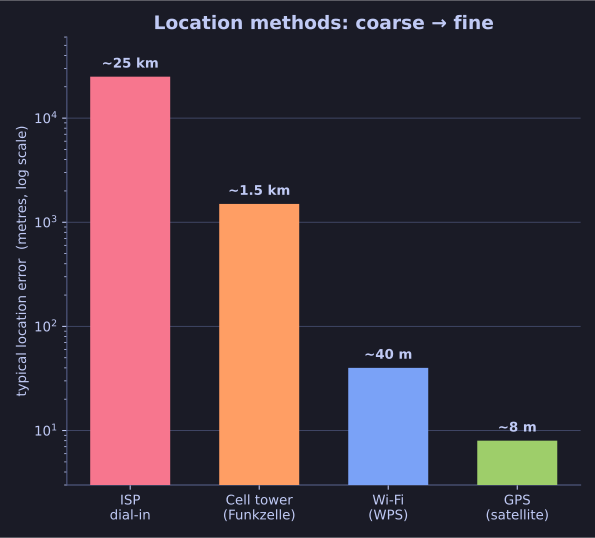
* Location methods compared — accuracy sharpens from ISP through cell and Wi-Fi to GPS. Figures are typical real-world magnitudes (illustrative), not exact. *
| Method | How it locates you | Accuracy |
|---|---|---|
| ISP dial-in point | Every connection goes through a geographically assignable ISP entry point | Coarse — city/region level |
| Cell tower (Funkzelle) | Phones are always connected to a cell; the cell's location gives a rough position | Approximate |
| Wi-Fi (WPS) | Matches visible Wi-Fi networks against a global database (built e.g. by Google Street View) | Precise |
| GPS | Satellite-based positioning | Highest accuracy |
Alarming statistic: just 4 space-time coordinates are enough to uniquely identify 95% of individuals — location data is extraordinarily identifying even in tiny quantities.
Tip: Wi-Fi positioning is why your phone can pinpoint you indoors where GPS struggles — it's reading the SSIDs around you against a pre-mapped database.
Go deeper:
 Wi-Fi positioning system (Wikipedia) — the mapped-network method giving precise, even indoor, location.
- Global Positioning System (Wikipedia) — the satellite method at the high-accuracy end.